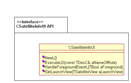
Figure 1: BLID Application Satellite Info API class diagram
BLID Application Satellite Info API loads the implementation at runtime and the implementation consists only of local objects.
BLID Application Satellite Info API consists of one class: CSatelliteInfoUI.
The API displays a dialog consisting of two views, indicating the satellite
data availability and quality. Satellite information is obtained by using
the first available positioning technology plug-in (PSY) which is capable
of providing satellite information. In the signal strength view, the dialog
displays the satellite IDs along with their signal strengths in the form of
bars. A satellite that is represented by a filled bar has a fix and a satellite
represented by an unfilled bar does not have a fix. In the firmament view
all visible satellites and their IDs are displayed on an imaginary firmament.
BLID Application Satellite Info API uses the service provided by Location Acquisition API to obtain satellite information. Using the services of BLID Application Satellite Info API requires the client to provide requestor data which generally is the name of the application. This requestor data will be used by the Location Framework for privacy verification in the future.
The use cases of BLID Application Satellite Info API are as follows:
Launching the Satellite Information dialog:
CSatelliteInfoUi class. The client may choose
to set the launch view using the method SetLaunchView().
Then calls the ExecuteLD() method with a string that provides
the requestor data used by Location Framework. The current instance of the
dialog is destroyed when this method exists or leaves.
Handling Foreground Events:
HandleForegroundEventL().
If the client application is switched to the background, the SatInfo library
stops requesting satellite information from Location Framework and when in
the foreground the satellite information is periodically requested from Location
Framework.

Figure 1: BLID Application Satellite Info API class diagram
It consists of only one class: CSatelliteInfoUI. It is
used to display a dialog indicating the satellite data availability and quality.