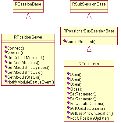
Figure 1: Client-server communication classes
The logical type of this API is Virtual Machine API and the technical type of this interface is client-server interface. The basis of Location Acquisition API is standard Symbian OS client-server implementation. The client application first connects to Location Server and then opens a sub-session through which the location information is obtained. It provides both asynchronous and synchronous methods, which should be taken into account to avoid unexpected blocking of the client application.
The following are the main use cases for Location Acquisition API. They can be grouped in two ways:
Location acquisition related operations
Positioning Module related operations
Location Acquisition API contains a number of classes, which implement all the functionality of the interface. In the following sections, the classes are grouped according to their roles or according to the functionality they provide together.
Figure 1 presents the class hierarchy and methods in both RPositionServer and RPositioner.
These classes implement the client-server communication with Location Server.
All requests from the client are sent through these classes. The figure also
contains the main classes and methods for changing the behavior of position
updates.

Figure 1: Client-server communication classes
RPositionServer represents a session to Location Server.
It is intended for establishing a connection with Location Server and for
obtaining general positioning module information. It is the primary class
for all client applications wishing to access Location Server. It can also
be used to obtain details of which positioning technologies are available
and of their current status.
RPositioner is used for requesting location information,
controlling update behavior and managing privacy. The purpose of RPositioner is
to create a second level connection (i.e. a sub-session) through which location
information is passed from Location Server.
Figure 2 shows the class hierarchy, the member data and significant methods for the standard position and data retrieval classes. Some members are not presented in the figure for the sake of clarity.
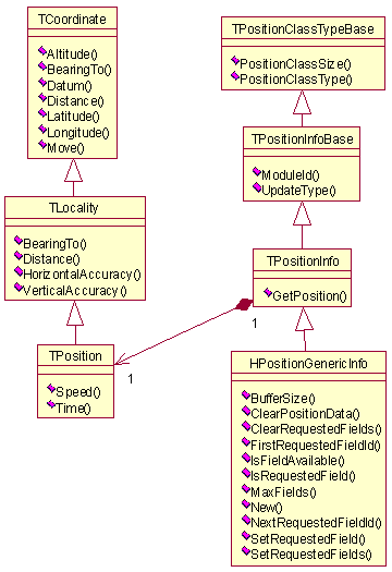
Figure 2: General position data classes
TPositionInfo is the main position data holder. It contains TPosition,
which encapsulates TLocality and TCoordinate information.
This is the standard parameter type passed to RPositioner when
a client application requests location information. It is a simple wrapper
class used to hold the identifier of the positioning technology that produced
the fix and a TPosition class that holds the location information
itself.
HPositionGenericInfo allows storing of arbitrary data
and it can also be used for client-server data transfer.
TPositionInfoBase is the base class for all position
information classes, both standard and extended. It is the operand of location
request calls.
The TPositionClassTypeBase class is used for determining
the data class on Location Server.
The data classes TCoordinate, TLocality and TPosition provide
certain utility methods. The following methods are provided by TCoordinate class:
Distance: This utility method calculates the distance
between 2 locations. The distance is calculated using a value of 6,371,010
metres as an approximation of the Earth's radius. Altitude is not involved
in the distance calculation.
An error code, indicating error in the input arguments, is returned if there is information missing for the calculation.
BearingTo: This utility method calculates the bearing
between source position to the target position without involving Altitude
in the calculation. The bearing is also calculated using a value of 6,371,010
meters as an approximation of the Earth's radius.
Error codes are returned for the following cases:
Move: This utility method calculates a new location for
a given TCoordinate object using bearing and distance information.
The calculation does not take Altitude into consideration. The TCoordinate object's
information is taken as the current location and calculations are based on
that point.
The TPosition class adds the following utility method
apart form those provided by TCoordinate class:
TPosition objects.
Speed is also calculated without any involvement of Altitude information.
The calculation is performed based on the timestamp and location information
in the TPosition classes. If the source and target position
time stamps are incorrect, the speed cannot be calculated, instead a return
an error code, indicating that the value is not defined, is returned.
The following time stamps are incorrect:
Figure 3 describes the hierarchy of the extended information retrieval classes provided by Location Acquisition API.
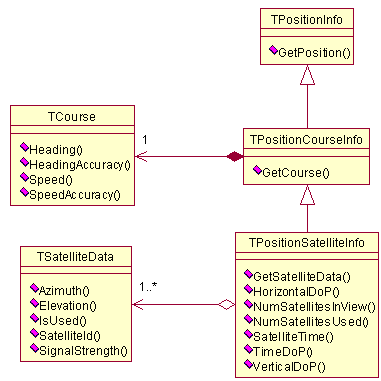
Figure 3: Extended data retrieval classes
Extended data retrieval classes are used when specific location information is needed. The extended data retrieval classes are not required to be supported by every positioning module. The Location Acquisition API user can also define new extended data retrieval classes.
The TPositionCourseInfo class is used to get course
information from a positioning module (if the module supports course information).
It contains a TCourse class object, which represents the
current speed of the device’s movement and the heading (direction) of the
movement. It also provides information about the accuracy of these parameters.
TPositionSatelliteInfo gives physical information about
the GPS network services used by the positioning device. This is a list of
the visible and used GPS satellites, their properties and common satellite
information. The satellites are described by TSatelliteData.
A client does not usually modify these classes. Instead, they are filled in by Location Server or the positioning module.
Figure 4 presents the classes for holding information about a positioning module and the significant methods for manipulating the data. The diagram also shows the main classes and methods for obtaining module status information.
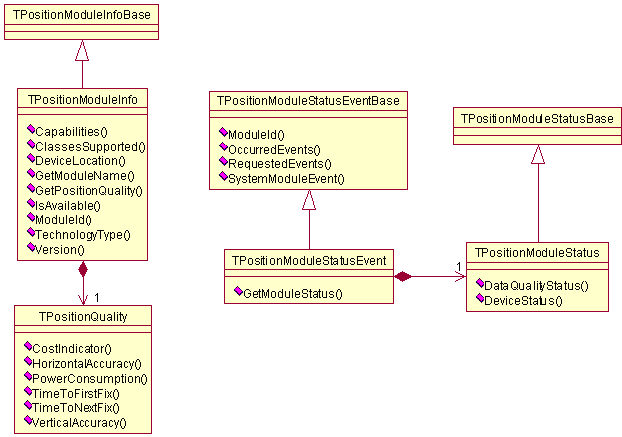
Figure 4: Module information, status and status event classes
Module information may be important for the client because it influences the whole location retrieving process.
The TPositionModuleInfo class represents general information
about a particular positioning module used by Location Server. In addition,
the class contains a TPositionQuality class to describe
the various parameters of the positioning module that influence location estimation.
This information can be used by the client or Location Server when looking
for an appropriate module for performing special tasks.
TPositionModuleStatus (and its parent class TPositionModuleStatusBase)
gives access to the current state of a particular module. A client may register
for notifications on module status changes. In this case, it receives information
in the form of TPositionModuleStatusEvent (from the base
class TPositionModuleStatusEventBase).
The TPositionQuality class defines quality parameters,
which are also called Quality of Position (QoP) and are used for presenting
positioning technology performance characteristics.
Figure 5 depicts the main classes used to specify a chain of requestors.
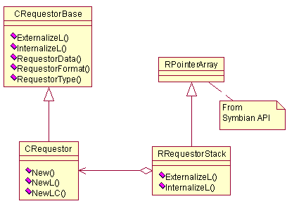
Figure 5: Privacy classes
The RRequestorStack class is used to transfer a list
of the requestors participating in the current location requests to Location
Server. Each item in the list is defined by a CRequestor definition
of the requestor.
Figure 6 depicts the main classes used to control location request related options.
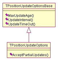
Figure 6: Update option classes
TPositionUpdateOptions is used by clients to define
the behavior of position updates sent to them from Location Server. It is
used as a parameter of RPositioner and RPositioner.